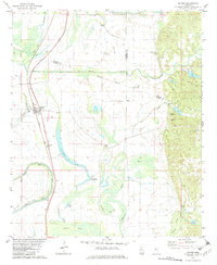
1982 Map of Cruger
USGS Topo · Published 1982About this map
Cruger serves as a central hub along the Illinois Central Gulf railroad in this early 1980s landscape, where the flat alluvial plains meet the rising hills of the bluff line. The area is defined by a dense network of water bodies, including Pinchback Lake, Tchula Lake, and Gibson Lake, reflecting the complex hydrology of the Yazoo-Mississippi Delta. Small communities and family-named locales like Oklahoma, Meeks, and Chicopa are scattered across the terrain, often anchored by rural congregations such as Gods Sanctuary Ch, Beth-el Chapel, and Gordon Chapel.
Find a feature on this map
40 named features on this map. Tap any name to fly to it.
Don’t see what you’re looking for? This feature index may not catch every label — zoom into the map to look around manually.
Map Details
Editions of this 1982 Cruger Map
This is the sole edition of this map. No revisions or reprints were ever made.
Other maps of this area

1940 · Seven Pines
USGS Topo · 1:62,500

1940 · Lexington
USGS Topo · 1:62,500

1940 · Mileston
USGS Topo · 1:62,500

1953 · Greenwood
USGS Topo · 1:250,000

1954 · Mileston
USGS Topo · 1:62,500

1956 · Greenwood
USGS Topo · 1:250,000

1957 · Lexington
USGS Topo · 1:62,500

1957 · Seven Pines
USGS Topo · 1:62,500

1958 · Seven Pines
USGS Topo · 1:62,500

1958 · Lexington
USGS Topo · 1:62,500