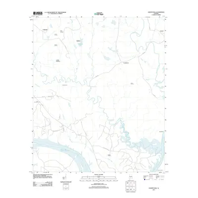
2011 Map of Crumptonia
USGS Topo · Published 2011About this map
Crumptonia and the surrounding riverlands of Dallas County are defined by the winding course of Chilatchee Creek and the broad waters of the Alabama River. This rural landscape is heavily marked by family-named landmarks and local burial grounds, including the Hardy Young Cemetery, Vaughn Cemetery, and Hennon Cemetery. The mapping reflects a region where traditional settlements like Cobbs Quarters and Sedgefield sit amidst a network of drainage ways such as Foster Creek and Hogan Creek.
Find a feature on this map
38 named features on this map. Tap any name to fly to it.
Don’t see what you’re looking for? This feature index may not catch every label — zoom into the map to look around manually.
Map Details
Editions of this 2011 Crumptonia Map
This is the sole edition of this map. No revisions or reprints were ever made.
Other maps of this area

1953 · Montgomery
USGS Topo · 1:250,000

1956 · Montgomery
USGS Topo · 1:250,000

1957 · Montgomery
USGS Topo · 1:250,000

1957 · Carlowville
USGS Topo · 1:62,500

1958 · Selma
USGS Topo · 1:62,500

1968 · Safford
USGS Topo · 1:24,000

1968 · Central Mills
USGS Topo · 1:24,000

1974 · Crumptonia
USGS Topo · 1:24,000

1974 · Catherine
USGS Topo · 1:24,000
1974 · Lee Long Bridge
USGS Topo · 1:24,000