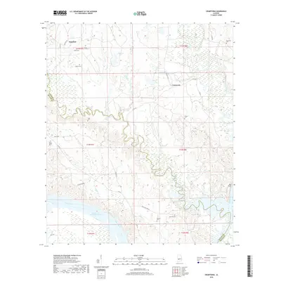
2018 Map of Crumptonia
USGS Topo · Published 2018About this map
Crumptonia and Sedgefield anchor this rural landscape in the Black Belt region, where the Alabama River carves the southern boundary of the quadrangle. The topography is defined by the winding course of Chilatchee Creek as it meanders toward the William 'Bill' Dannelly Reservoir, a major waterway that dominates the bottom of the sheet. This area is historically significant for its dispersed family-named burial grounds, such as Vaughn Cem, Hardy-Young Cem, and Hennon Cem, reflecting the early settlement patterns of Dallas and Wilcox Counties. The intricate drainage network, including Bogue Chitto Creek and Hogan Cr, suggests a landscape historically tied to the river's floodplain. Higher elevations appear at Red Bluff, providing a contrast to the marshy lowlands near Sedgefield Lake. The map serves as a vital tool for genealogists, preserving the location of numerous small cemeteries like Cobbs Cem and Athens Cem that might otherwise be overlooked.
Find a feature on this map
39 named features on this map. Tap any name to fly to it.
Don’t see what you’re looking for? This feature index may not catch every label — zoom into the map to look around manually.
Map Details
Editions of this 2018 Crumptonia Map
This is the sole edition of this map. No revisions or reprints were ever made.
Other maps of this area

1953 · Montgomery
USGS Topo · 1:250,000

1956 · Montgomery
USGS Topo · 1:250,000

1957 · Montgomery
USGS Topo · 1:250,000

1957 · Carlowville
USGS Topo · 1:62,500

1958 · Selma
USGS Topo · 1:62,500

1968 · Safford
USGS Topo · 1:24,000

1968 · Central Mills
USGS Topo · 1:24,000

1974 · Crumptonia
USGS Topo · 1:24,000

1974 · Catherine
USGS Topo · 1:24,000
1974 · Lee Long Bridge
USGS Topo · 1:24,000