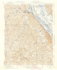
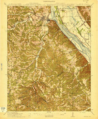
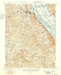
1915 Map of Crystal City
USGS Topo · Published 1939About this map
The Mississippi River corridor dominates this region at a time when river traffic and rail infrastructure defined local commerce. Major rail lines, including the St. Louis Iron Mountain and Southern RR and the Mississippi River and Bonne Terre RR, connect industrial hubs like Crystal City and Festus to the broader regional network. The rugged terrain away from the river is dotted with isolated rural settlements such as Hematite, Danby, and Valles Mines, many of which were supported by local mineral extraction and timber.
Find a feature on this map
85 named features on this map. Tap any name to fly to it.
Don’t see what you’re looking for? This feature index may not catch every label — zoom into the map to look around manually.
Map Details
Editions of this 1915 Crystal City Map
4 editions found

Other maps of this area

1901 · De Soto
USGS Topo · 1:125,000

1904 · Farmington
USGS Topo · 1:62,500

1905 · Bonneterre
USGS Topo · 1:62,500

1906 · Farmington
USGS Topo · 1:62,500

1907 · Weingarten
USGS Topo · 1:62,500

1909 · Weingarten
USGS Topo · 1:62,500

1910 · Waterloo
USGS Topo · 1:62,500

1912 · Kimmswick
USGS Topo · 1:62,500

1913 · Waterloo
USGS Topo · 1:62,500

1915 · Renault
USGS Topo · 1:62,500
Featured Places
- Festus, River View Township
- Crystal City, River View Township
- Herculaneum, Joachim Township
- Olympian Village, Plattin Township
- Valley View, MO