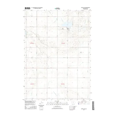
2015 Map of Crystal Lake
USGS Topo · Published 2015About this map
Crystal Lake sits at the heart of this North Central Iowa landscape, providing a geographic anchor for the town of the same name. This 2015 survey reveals an environment defined by the headwaters of multiple drainage systems, including the Boone River and the W Br Iowa River. The land is heavily managed for agriculture, evidenced by an extensive network of water control features such as Drainage Ditch Number 39 and Drainage Ditch Number 114. Near the town site, the Crystal Township Cem serves as a primary point of interest for genealogists tracing local families.
Find a feature on this map
36 named features on this map. Tap any name to fly to it.
Don’t see what you’re looking for? This feature index may not catch every label — zoom into the map to look around manually.
Map Details
Editions of this 2015 Crystal Lake Map
This is the sole edition of this map. No revisions or reprints were ever made.
Other maps of this area

1954 · Mason City
USGS Topo · 1:250,000

1957 · Mason City
USGS Topo · 1:250,000

1958 · Mason City
USGS Topo · 1:250,000

1972 · Buffalo Center SW
USGS Topo · 1:24,000

1972 · Forest City
USGS Topo · 1:24,000

1972 · Hayfield
USGS Topo · 1:24,000

1972 · Crystal Lake
USGS Topo · 1:24,000
1972 · Wesley
USGS Topo · 1:24,000
1972 · Thompson
USGS Topo · 1:24,000
1972 · Duncan
USGS Topo · 1:24,000