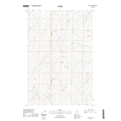
2020 Map of Crystal Peak
USGS Topo · Published 2020About this map
Crystal Peak and Santa Peak dominate the high terrain along the border of Benewah and Shoshone counties, defining a landscape of sharp ridges and deep creek drainages. This 2020 study reveals a network of Forest Service and development roads, including Nat For Dev Rd 132 and Renfro Creek Rd, that provide access to the timbered slopes. The drainage patterns are intricate, with Mica Cr and Renfro Cr flowing away from the central peaks. The map details a transition from uninhabited forest lands to more localized residential developments in the southwest, marked by names like Upriver View Dr and Crystal Peak Rd. Prominent landmarks such as Gold Ridge, Blackwell Hump, and Bogus Point emphasize the topographical variation of this Idaho Panhandle region.
Find a feature on this map
45 named features on this map. Tap any name to fly to it.
Don’t see what you’re looking for? This feature index may not catch every label — zoom into the map to look around manually.
Map Details
Editions of this 2020 Crystal Peak Map
This is the sole edition of this map. No revisions or reprints were ever made.
Other maps of this area

1955 · Spokane
USGS Topo · 1:250,000

1957 · Calder
USGS Topo · 1:62,500

1957 · St. Joe
USGS Topo · 1:62,500

1958 · Spokane
USGS Topo · 1:250,000

1961 · Fernwood
USGS Topo · 1:62,500
1969 · Merry Creek
USGS Topo · 1:24,000

1969 · Huckleberry Mtn
USGS Topo · 1:24,000

1981 · St Maries
USGS Topo · 1:100,000
1985 · St. Joe Baldy
USGS Topo · 1:24,000
1985 · St. Joe
USGS Topo · 1:24,000