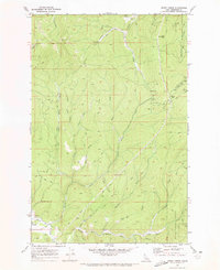
1969 Map of Merry Creek
USGS Topo · Published 1973About this map
Timber and topography dominate this landscape within the St Joe National Forest as it was surveyed in the late 1960s. The settlement of Clarkia sits at the southwestern edge, adjacent to the Middle Fork St Maries River. The map reveals the intricate legacy of industrial logging through the extensive remains of an Old Railroad Grade and a specific segment marked The Incline, which once served to move timber through the steep drainage basins of Merry Creek and its many tributaries like Ashenfelter Creek and Fiewsie Creek. High elevation points such as Swan Peak and Hobo Pass define the ridgelines, while the presence of a Radio Facility and a Borrow Pit indicate modern infrastructure developments of the era. The terrain is crisscrossed by an extensive network of Jeep Trails and Pack Trails, serving as the primary arteries through the dense forest and over the mountain passes.
Find a feature on this map
30 named features on this map. Tap any name to fly to it.
Don’t see what you’re looking for? This feature index may not catch every label — zoom into the map to look around manually.
Map Details
Editions of this 1969 Merry Creek Map
2 editions found
Other maps of this area

1955 · Pullman
USGS Topo · 1:250,000

1955 · Spokane
USGS Topo · 1:250,000

1958 · Spokane
USGS Topo · 1:250,000

1958 · Pullman
USGS Topo · 1:250,000

1961 · Fernwood
USGS Topo · 1:62,500

1961 · Bovill
USGS Topo · 1:62,500

1969 · Marble Mountain
USGS Topo · 1:24,000

1969 · Anthony Peak
USGS Topo · 1:24,000

1969 · Grandmother Mtn
USGS Topo · 1:24,000
1969 · Grice Ridge
USGS Topo · 1:24,000