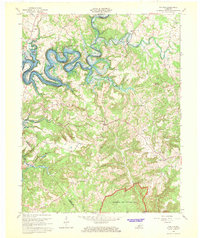
1966 Map of Cub Run
USGS Topo · Published 1968About this map
The Nolin River Reservoir dominates the northwestern landscape of this region, its winding shoreline carving through the deep valleys of the Nolin River. This mid-century view shows a rural Kentucky landscape transitioning as the reservoir boundary shapes local development, with small fishing and resort communities like Sportsmens Paradise and Roseburg emerging along the water's edge. To the south, the terrain levels out as it enters the northern reaches of Mammoth Cave National Park, characterized by unique karst topography such as the Big Sink.
Find a feature on this map
33 named features on this map. Tap any name to fly to it.
Don’t see what you’re looking for? This feature index may not catch every label — zoom into the map to look around manually.
Map Details
Editions of this 1966 Cub Run Map
This is the sole edition of this map. No revisions or reprints were ever made.
Other maps of this area

1922 · Mammoth Cave
USGS Topo · 1:62,500

1923 · Mammoth Cave
USGS Topo · 1:62,500

1925 · Cub Run
USGS Topo · 1:62,500

1934 · Munfordville
USGS Topo · 1:48,000

1935 · Horse Cave
USGS Topo · 1:48,000

1937 · Munfordville
USGS Topo · 1:62,500

1938 · Horse Cave
USGS Topo · 1:62,500

1953 · Munfordville
USGS Topo · 1:24,000

1954 · Evansville
USGS Topo · 1:250,000

1954 · Horse Cave
USGS Topo · 1:24,000