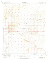
1954 Map of Cuddeback Lake
USGS Topo · Published 1963About this map
The Cuddeback Lake (Depression) dominates the southwestern portion of this mid-century survey, surrounded by the arid expanses of the Lava Mountains and the Black Hills. Large tracts of the landscape are designated as a Naval Reservation, reflecting the region's mid-century importance for military testing and training. Isolated water sources like Blackwater Well, a Windmill, and Wells (Alkali) provide crucial points of orientation in a terrain otherwise characterized by its namesake lake and remote landmarks like Almond Mountain.
Find a feature on this map
17 named features on this map. Tap any name to fly to it.
Don’t see what you’re looking for? This feature index may not catch every label — zoom into the map to look around manually.
Map Details
Editions of this 1954 Cuddeback Lake Map
3 editions found

Other maps of this area

1903 · Randsburg
USGS Topo · 1:62,500

1911 · Randsburg
USGS Topo · 1:62,500

1912 · Randsburg
USGS Topo · 1:62,500

1915 · Searles Lake
USGS Topo · 1:250,000

1947 · Trona
USGS Topo · 1:250,000

1948 · Trona
USGS Topo · 1:250,000

1949 · Searles Lake
USGS Topo · 1:62,500

1950 · Searles Lake
USGS Topo · 1:62,500

1950 · Wingate Pass
USGS Topo · 1:62,500

1951 · Wingate Pass
USGS Topo · 1:62,500