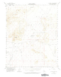
1954 Map of Cuddeback Lake
USGS Topo · Published 1972About this map
Cuddeback Lake dominates the southwestern quadrant of this high-desert survey, marking a low point in a landscape defined by volcanic landforms and arid basins. The Lava Mountains and the Black Hills provide significant relief across the central and northern sections, where the Naval Reservation boundary indicates the specialized military use of this terrain in the mid-1950s. Historically significant water sources, such as Blackwater Well and several Wells (Alkali), are critical landmarks for understanding early travel and survival in this portion of San Bernardino County.
Find a feature on this map
15 named features on this map. Tap any name to fly to it.
Don’t see what you’re looking for? This feature index may not catch every label — zoom into the map to look around manually.
Map Details
Editions of this 1954 Cuddeback Lake Map
3 editions found

Other maps of this area

1903 · Randsburg
USGS Topo · 1:62,500

1911 · Randsburg
USGS Topo · 1:62,500

1912 · Randsburg
USGS Topo · 1:62,500

1915 · Searles Lake
USGS Topo · 1:250,000

1947 · Trona
USGS Topo · 1:250,000

1948 · Trona
USGS Topo · 1:250,000

1949 · Searles Lake
USGS Topo · 1:62,500

1950 · Searles Lake
USGS Topo · 1:62,500

1950 · Wingate Pass
USGS Topo · 1:62,500

1951 · Wingate Pass
USGS Topo · 1:62,500