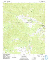
1991 Map of Cuddy Valley
USGS Topo · Published 1991About this map
Tecuya Ridge and the dramatic geological expression of the San Andreas Rift Zone define this portion of the Los Padres National Forest near the border of Kern and Ventura counties. The landscape is characterized by the high-elevation basins of Cuddy Valley and Lockwood Valley, where early 1990s residential developments like Pinon Pines Estates and Pine Mountain Club sit alongside older agricultural and ranching sites. Evidence of historical land use appears in the Stauffer (Site) and a solitary Adobe in the southern valley, while various borrow pits and mine dumps point to the area's mineral extraction history. The presence of numerous campsites, such as McGill Campground and Chuchupate Campground, alongside the Chuchupate Ranger Station, reflects a landscape heavily managed for both conservation and mountain recreation at the close of the twentieth century.
Find a feature on this map
41 named features on this map. Tap any name to fly to it.
Don’t see what you’re looking for? This feature index may not catch every label — zoom into the map to look around manually.
Map Details
Editions of this 1991 Cuddy Valley Map
2 editions found
Other maps of this area

1903 · Mt. Pinos
USGS Topo · 1:125,000

1903 · Tejon
USGS Topo · 1:125,000

1942 · Eagle Rest Peak
USGS Topo · 1:24,000

1942 · Tecuya Creek
USGS Topo · 1:24,000

1942 · Frazier Mountain
USGS Topo · 1:24,000

1943 · San Guillermo
USGS Topo · 1:24,000

1943 · Sawmill Mountain
USGS Topo · 1:24,000

1943 · Cuddy Valley
USGS Topo · 1:24,000

1943 · Lockwood Valley
USGS Topo · 1:24,000
1944 · San Guillermo
USGS Topo · 1:31,680