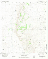
1983 Map of Cuesta Del Burro NW
USGS Topo · Published 1983About this map
Mc Minn Camp stands as a primary point of human activity in this arid stretch of Presidio County, surveyed during the mid-1970s and published in the early 1980s. The landscape is defined by the broad expanse of Cleveland Flat and the drainage of Wild Horse Draw, where survival and ranching operations are traced through a network of isolated water sources. Named landmarks like Brite Well, Freemont Windmill, and Wooly Well provide a look into the infrastructure required for life in the West Texas high desert. Further evidence of local ranching and transit includes several Landing Strips and numerous reservoirs such as Babcock Tank and Parker Tank. These features, alongside the intermittent flow of Cat Creek, illustrate how the geography was managed and occupied in the years before modern ranching shifts.
Find a feature on this map
17 named features on this map. Tap any name to fly to it.
Don’t see what you’re looking for? This feature index may not catch every label — zoom into the map to look around manually.
Map Details
Editions of this 1983 Cuesta Del Burro NW Map
This is the sole edition of this map. No revisions or reprints were ever made.
Other maps of this area

1895 · Marfa
USGS Topo · 1:125,000

1896 · San Carlos
USGS Topo · 1:125,000

1959 · Marfa
USGS Topo · 1:250,000

1965 · Marfa
USGS Topo · 1:250,000
1978 · Capote Peak
USGS Topo · 1:24,000

1979 · Ruidosa Hot Springs
USGS Topo · 1:24,000

1979 · Capote Falls
USGS Topo · 1:24,000

1983 · Cuesta Del Burro East
USGS Topo · 1:24,000
1983 · Cuesta Del Burro West
USGS Topo · 1:24,000
1983 · Oak Hills North
USGS Topo · 1:24,000