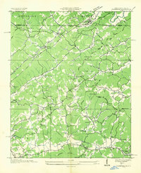
1935 Map of Culberson
USGS Topo · Published 1935About this map
Louisville and Nashville tracks cross the state line near Culberson, illustrating the vital rail and mountain gap connections between North Carolina and Georgia during the mid-1930s. The landscape is defined by a dense network of water-powered industry and community hubs, including Forge Mill, Wrights Mill, and Mashburn Mill. Rural life is anchored by numerous small centers like Sweet Gum and Morganton, alongside landmarks such as Moores Chapel and Flint Grove Sch.
Find a feature on this map
83 named features on this map. Tap any name to fly to it.
Don’t see what you’re looking for? This feature index may not catch every label — zoom into the map to look around manually.
Map Details
Editions of this 1935 Culberson Map
This is the sole edition of this map. No revisions or reprints were ever made.
Other maps of this area

1888 · Ellijay
USGS Topo · 1:125,000

1892 · Ellijay
USGS Topo · 1:125,000

1893 · Murphy
USGS Topo · 1:125,000

1898 · Ellijay
USGS Topo · 1:125,000

1911 · Ellijay
USGS Topo · 1:125,000

1914 · Murphy
USGS Topo · 1:125,000

1934 · Murphy
USGS Topo · 1:24,000

1934 · Persimmon Creek
USGS Topo · 1:24,000

1934 · Murphy
USGS Topo · 1:48,000

1935 · Ivylog
USGS Topo · 1:24,000