
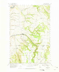
1958 Map of Culdesac
USGS Topo · Published 1960About this map
The Slickpoo St Joseph Mission and Glasby Indian Cemetery reflect the complex cultural history of Nez Perce County, where Catholic missions and Indigenous grounds meet the high agricultural plateaus. The landscape is defined by the dramatic elevation changes between the Clearwater River and the fertile Camas Prairie, connected by the winding Camas Prairie RR and the Winchester Grade. The engineering required to navigate Culdesac Hill is evident in the numerous tunnels and the railroad's path through Big Canyon. Rural life in the late 1950s centered around scattered educational and religious hubs like Forest Lawn Sch and Coldsprings School, alongside vanished locations such as Chesley (Site) and the isolated German Settlement.
Find a feature on this map
48 named features on this map. Tap any name to fly to it.
Don’t see what you’re looking for? This feature index may not catch every label — zoom into the map to look around manually.
Map Details
Editions of this 1958 Culdesac Map
2 editions found
Other maps of this area

1924 · Kamiah
USGS Topo · 1:125,000

1946 · Limekiln Rapids
USGS Topo · 1:62,500

1955 · Pullman
USGS Topo · 1:250,000

1958 · Pullman
USGS Topo · 1:250,000

1958 · Lapwai
USGS Topo · 1:24,000

1958 · Sweetwater
USGS Topo · 1:24,000

1958 · Lewiston Orchards
USGS Topo · 1:62,500

1961 · Kendrick
USGS Topo · 1:62,500

1961 · Ahsahka
USGS Topo · 1:62,500

1961 · Moscow
USGS Topo · 1:62,500