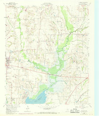
1960 Map of Culleoka
USGS Topo · Published 1969About this map
Lavon Reservoir dominates the southern reaches of this Collin County landscape, its normal pool elevation of 472 feet defining the local geography as it appeared in the late 1950s and 1960s. The northern section is a network of small farming communities and family landmarks, including Altoga, Verona, and Climax. Genealogists will find significant detail in the numerous burial grounds and spiritual centers such as Verona Cem, Pleasant Grove Cem, and Henslee Chapel.
Find a feature on this map
24 named features on this map. Tap any name to fly to it.
Don’t see what you’re looking for? This feature index may not catch every label — zoom into the map to look around manually.
Map Details
Editions of this 1960 Culleoka Map

Other maps of this area

1924 · Farmersville 3-c
USGS Topo · 1:48,000

1924 · Mc Kinney 4-d
USGS Topo · 1:48,000

1929 · McKinney
USGS Topo · 1:62,500

1930 · Farmersville
USGS Topo · 1:62,500

1954 · Sherman
USGS Topo · 1:250,000

1958 · Sherman
USGS Topo · 1:250,000

1959 · Wylie
USGS Topo · 1:24,000

1960 · McKinney East
USGS Topo · 1:24,000

1960 · Blue Ridge
USGS Topo · 1:24,000

1960 · Pike
USGS Topo · 1:24,000