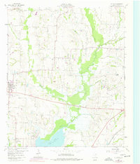
1960 Map of Culleoka
USGS Topo · Published 1977About this map
Sister Grove Creek and Pilot Grove Creek converge in this agricultural landscape of Collin County, flowing southward into the northern reaches of Lavon Lake. The terrain is defined by low-lying branches and the Hays Hills, where several family and community burial sites such as Van Winkle Cem, Rike Cem, and Houston Cem provide significant points of interest for genealogical research.
Find a feature on this map
29 named features on this map. Tap any name to fly to it.
Don’t see what you’re looking for? This feature index may not catch every label — zoom into the map to look around manually.
Map Details
Editions of this 1960 Culleoka Map

Other maps of this area

1924 · Farmersville 3-c
USGS Topo · 1:48,000

1924 · Mc Kinney 4-d
USGS Topo · 1:48,000

1929 · McKinney
USGS Topo · 1:62,500

1930 · Farmersville
USGS Topo · 1:62,500

1954 · Sherman
USGS Topo · 1:250,000

1958 · Sherman
USGS Topo · 1:250,000

1959 · Wylie
USGS Topo · 1:24,000

1960 · McKinney East
USGS Topo · 1:24,000

1960 · Blue Ridge
USGS Topo · 1:24,000

1960 · Pike
USGS Topo · 1:24,000