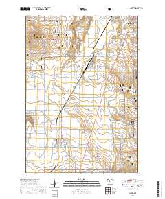
2020 Map of Culver
USGS Topo · Published 2020About this map
The Crooked River National Grassland dominates the western and southeastern reaches of this high desert landscape, framing a productive agricultural corridor centered on Madras and the smaller settlements of Metolius and Culver. The terrain is defined by dramatic geologic shifts, including the deep Crooked River Gorge and the elevation of Round Butte, while the flatlands are carved by Dry Canyon and Haystack Draw. This area shows a dense network of rural roads such as SW Highland Ln and SW Franklin Ln that support the local farming economy. Genealogists will find historical markers at the German Cem and the Culver IOOF Cem, which anchor the community's history within Jefferson County. The map reflects a modern era where established irrigation and road systems intersect with protected federal grasslands.
Find a feature on this map
35 named features on this map. Tap any name to fly to it.
Don’t see what you’re looking for? This feature index may not catch every label — zoom into the map to look around manually.
Map Details
Editions of this 2020 Culver Map
This is the sole edition of this map. No revisions or reprints were ever made.
Other maps of this area

1926 · Bend
USGS Topo · 1:125,000

1928 · Madras
USGS Topo · 1:125,000

1929 · Bend
USGS Topo · 1:125,000

1931 · Madras
USGS Topo · 1:125,000

1955 · Bend
USGS Topo · 1:250,000

1957 · Bend
USGS Topo · 1:250,000

1958 · Bend
USGS Topo · 1:250,000

1962 · Opal City
USGS Topo · 1:24,000
1962 · Gray Butte
USGS Topo · 1:24,000
1962 · Steelhead Falls
USGS Topo · 1:24,000