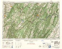
1948 Map of Cumberland
USGS Topo · Published 1957About this map
Cumberland serves as a central hub in this post-war landscape, where the ridge-and-valley terrain of the Allegheny Mountains dictates the path of industry and transit. This 1:250,000 scale survey illustrates the heavy reliance on rail networks like the B and O RR, Western Maryland Ry, and Pennsylvania RR to navigate the steep gaps between Negro Mountain and Sideling Hill. The map captures the region during a period of industrial activity, showing the connectivity between coal and manufacturing centers such as Morgantown, Uniontown, and Connellsville.
Find a feature on this map
81 named features on this map. Tap any name to fly to it.
Don’t see what you’re looking for? This feature index may not catch every label — zoom into the map to look around manually.
Map Details
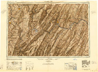
Editions of this 1948 Cumberland Map
3 editions found

Other maps of this area

1884 · Harpers Ferry
USGS Topo · 1:125,000

1886 · St. George
USGS Topo · 1:125,000

1889 · Beverly
USGS Topo · 1:125,000

1891 · Harpers Ferry
USGS Topo · 1:125,000

1891 · St. George
USGS Topo · 1:125,000

1891 · Romney
USGS Topo · 1:125,000

1892 · Beverly
USGS Topo · 1:125,000

1892 · Franklin
USGS Topo · 1:125,000

1892 · Woodstock
USGS Topo · 1:125,000

1893 · Buckhannon
USGS Topo · 1:125,000