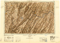
1948 Map of Cumberland
USGS Topo · Published 1950About this map
The industrial and transport corridors of the mid-Atlantic mountains are clearly defined here, centered on the strategic hub of Cumberland where the Potomac River and B & O RR navigate the dramatic ridges. The map illustrates the complex geology of the Allegheny Front and the series of parallel ridges like Wills Mountain and Sideling Hill that dictated settlement patterns in Maryland, West Virginia, and Pennsylvania.
Find a feature on this map
150 named features on this map. Tap any name to fly to it.
Don’t see what you’re looking for? This feature index may not catch every label — zoom into the map to look around manually.
Map Details
Editions of this 1948 Cumberland Map
3 editions found

Other maps of this area

1884 · Harpers Ferry
USGS Topo · 1:125,000

1886 · St. George
USGS Topo · 1:125,000

1889 · Beverly
USGS Topo · 1:125,000

1891 · Harpers Ferry
USGS Topo · 1:125,000

1891 · St. George
USGS Topo · 1:125,000

1891 · Romney
USGS Topo · 1:125,000

1892 · Beverly
USGS Topo · 1:125,000

1892 · Franklin
USGS Topo · 1:125,000

1892 · Woodstock
USGS Topo · 1:125,000

1893 · Buckhannon
USGS Topo · 1:125,000