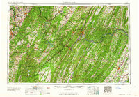
1962 Map of Cumberland
USGS Topo · Published 1962About this map
Cumberland and Morgantown anchor this mid-century topographic perspective of the central Appalachians, where the borders of Maryland, Pennsylvania, West Virginia, and Virginia converge. The landscape is defined by the high ridges of the Allegheny Mountains, including Negro Mountain and Savage Mountain, which separate the western-flowing waters of the Youghiogheny River and Monongahela River from the Potomac River drainage. Industrial and recreational hubs are visible at Deep Creek Lake and Westernport, while the massive green expanse of the Monongahela National Forest and George Washington National Forest highlights the region's preserved wilderness areas.
Find a feature on this map
272 named features on this map. Tap any name to fly to it.
Don’t see what you’re looking for? This feature index may not catch every label — zoom into the map to look around manually.
Map Details
Editions of this 1962 Cumberland Map
This is the sole edition of this map. No revisions or reprints were ever made.
Other maps of this area

1884 · Harpers Ferry
USGS Topo · 1:125,000

1886 · St. George
USGS Topo · 1:125,000

1889 · Beverly
USGS Topo · 1:125,000

1891 · Harpers Ferry
USGS Topo · 1:125,000

1891 · St. George
USGS Topo · 1:125,000

1891 · Romney
USGS Topo · 1:125,000

1892 · Beverly
USGS Topo · 1:125,000

1892 · Franklin
USGS Topo · 1:125,000

1892 · Woodstock
USGS Topo · 1:125,000

1893 · Buckhannon
USGS Topo · 1:125,000