
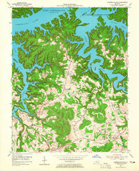
1954 Map of Cumberland City
USGS Topo · Published 1955About this map
Lake Cumberland dominates this 1954 landscape, its fingers stretching into the winding valleys of Indian Creek and Otter Creek. The map documents a period of significant transition as the reservoir, subject to controlled inundation to 760 feet, reshaped the local geography of Clinton and Wayne Counties. Settlements like Cumberland City and the Watauga P O remain central hubs, connected by a network of unimproved and light-duty roads that navigate the surrounding ridges. Higher elevations are marked by Short Mountain and Haw Knob, providing a stark contrast to the newly submerged creek beds.
Find a feature on this map
52 named features on this map. Tap any name to fly to it.
Don’t see what you’re looking for? This feature index may not catch every label — zoom into the map to look around manually.
Map Details
Editions of this 1954 Cumberland City Map
2 editions found
Other maps of this area

1911 · Monticello
USGS Topo · 1:62,500

1914 · Monticello
USGS Topo · 1:62,500

1929 · Byrdstown
USGS Topo · 1:62,500

1934 · Pall Mall
USGS Topo · 1:62,500

1953 · Parnell
USGS Topo · 1:24,000

1953 · Wolf Creek Dam
USGS Topo · 1:24,000

1953 · Creelsboro
USGS Topo · 1:24,000

1953 · Jamestown
USGS Topo · 1:24,000

1954 · Jabez
USGS Topo · 1:24,000

1954 · Albany
USGS Topo · 1:24,000