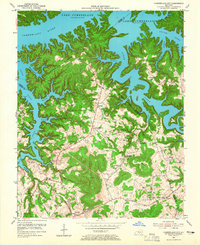
1954 Map of Cumberland City
USGS Topo · Published 1965About this map
Lake Cumberland dominates the northern landscape of this mid-century survey, its fingers reaching deep into the jagged valleys of the Cumberland River basin. Following the impoundment of the lake, the high ground remains dotted with small agrarian hubs like Cumberland City and Watauga. The terrain is defined by prominent elevations such as Short Mountain and Cedar Knob, where the local road network winds around steep topography to connect numerous family-named landmarks and rural institutions. Genealogists will find a wealth of specific data points, from the McWhorter Cem and Cabell Clipper Cem to a series of community schools including Pine Grove Sch and Pleasant Ridge Sch. The presence of Grider Hill Dock reflects the region's mid-century transition toward water-based recreation and commerce along the newly established shoreline.
Find a feature on this map
49 named features on this map. Tap any name to fly to it.
Don’t see what you’re looking for? This feature index may not catch every label — zoom into the map to look around manually.
Map Details
Editions of this 1954 Cumberland City Map
2 editions found
Other maps of this area

1911 · Monticello
USGS Topo · 1:62,500

1914 · Monticello
USGS Topo · 1:62,500

1929 · Byrdstown
USGS Topo · 1:62,500

1934 · Pall Mall
USGS Topo · 1:62,500

1953 · Parnell
USGS Topo · 1:24,000

1953 · Wolf Creek Dam
USGS Topo · 1:24,000

1953 · Creelsboro
USGS Topo · 1:24,000

1953 · Jamestown
USGS Topo · 1:24,000

1954 · Jabez
USGS Topo · 1:24,000

1954 · Cumberland City
USGS Topo · 1:24,000