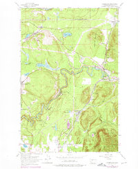
1953 Map of Cumberland
USGS Topo · Published 1976About this map
Industrial activity and heavy rail infrastructure dominate this landscape at the western edge of the Cascades. The Green River carves a winding path through the center of the sheet, flanked by the Burlington Northern and Milwaukee St Paul and Pacific rail lines. These corridors served a network of company towns and mining outposts including Cumberland, Bayne, Palmer, and Ravensdale. While the northern section is protected as the Cedar River Watershed, the southern portions show the footprints of extractive industry with labeled Coal deposits and a Borrow Pit. Numerous small bodies of water like Deep Lake and Lake No 12 are scattered between the peaks of Sugarloaf Mountain and Enumclaw Mtn, illustrating a terrain where steep timbered ridges meet the high-traffic valley floors of the mid-20th century.
Find a feature on this map
46 named features on this map. Tap any name to fly to it.
Don’t see what you’re looking for? This feature index may not catch every label — zoom into the map to look around manually.
Map Details
Editions of this 1953 Cumberland Map
4 editions found

Other maps of this area

1897 · Tacoma
USGS Topo · 1:125,000

1900 · Tacoma
USGS Topo · 1:125,000

1913 · Cedar Lake
USGS Topo · 1:125,000

1942 · Lake Tapps
USGS Topo · 1:62,500

1944 · Lake Tapps
USGS Topo · 1:62,500

1949 · Maple Valley
USGS Topo · 1:24,000

1949 · Black Diamond
USGS Topo · 1:24,000

1953 · North Bend
USGS Topo · 1:24,000

1953 · Hobart
USGS Topo · 1:24,000

1953 · Eagle Gorge
USGS Topo · 1:24,000