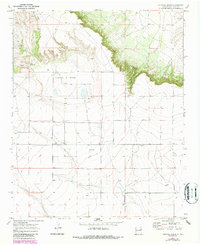
1970 Map of Cunavea Basin
USGS Topo · Published 1987About this map
The Caprock dominates this 1970s landscape, forming a dramatic escarpment that overlooks the lower Cunavea Basin. This transition between the high mesa and the basin floor is marked by erosion-carved features like Long Canyon and Stanford Canyon, which cut through the rugged rim. Water is the primary driver of development in this arid New Mexico terrain, evidenced by the strategic placement of Hart Springs, Alamo Spring, and various man-made installations including a Water Tank and a significant Ditch. Land use is primarily agricultural and industrial, with several Gravel Pit sites scattered across the southern basin floor and a network of fence lines indicating active ranching. A prominent Knoll in the southeast provides a distinct navigational landmark amidst the relatively flat basin terrain.
Find a feature on this map
13 named features on this map. Tap any name to fly to it.
Don’t see what you’re looking for? This feature index may not catch every label — zoom into the map to look around manually.
Map Details
Editions of this 1970 Cunavea Basin Map
2 editions found
Other maps of this area

1954 · Fort Sumner
USGS Topo · 1:250,000

1954 · Clovis
USGS Topo · 1:250,000

1958 · Fort Sumner
USGS Topo · 1:250,000

1958 · Clovis
USGS Topo · 1:250,000

1968 · Hassell
USGS Topo · 1:24,000

1968 · Ima SE
USGS Topo · 1:24,000
1968 · Ima
USGS Topo · 1:24,000

1970 · Jordan
USGS Topo · 1:24,000

1970 · Quay
USGS Topo · 1:24,000
1970 · Circles S Mesa
USGS Topo · 1:24,000