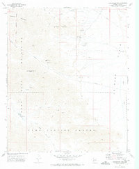
1971 Map of Cunningham Mtn
USGS Topo · Published 1974About this map
Dome Rock Mountains and the surrounding high desert terrain define this southwestern Arizona landscape during the early 1970s. The region is marked by significant mineral extraction history, evidenced by a cluster of named workings such as the Copper Bottom Mine, Yellow Dog Mine, and Cinnabar Mine. These sites are linked by rugged jeep trails and passes, including Copper Bottom Pass and Weaver Pass, which navigate the steep elevations between Sawtooth Mountain and Cunningham Mtn.
Find a feature on this map
27 named features on this map. Tap any name to fly to it.
Don’t see what you’re looking for? This feature index may not catch every label — zoom into the map to look around manually.
Map Details
Editions of this 1971 Cunningham Mtn Map
2 editions found
Other maps of this area

1933 · Cunningham Mtn
USGS Topo · 1:48,000

1934 · Trigo Peaks
USGS Topo · 1:48,000

1939 · Trigo Peaks
USGS Topo · 1:62,500

1940 · Dome Rock Mts
USGS Topo · 1:62,500

1942 · Blythe
USGS Topo · 1:250,000

1954 · Salton Sea
USGS Topo · 1:250,000

1954 · Trigo Peaks
USGS Topo · 1:62,500

1955 · Salton Sea
USGS Topo · 1:250,000
1955 · La Paz Mtn
USGS Topo · 1:24,000

1959 · Salton Sea
USGS Topo · 1:250,000