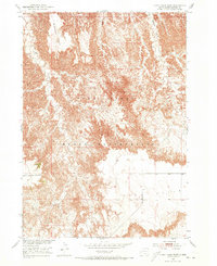
1951 Map of Cuny Table West
USGS Topo · Published 1973About this map
Pine Ridge Indian Reservation land dominates this landscape, showing the complex high-plateau geography of South Dakota during the early 1950s. The terrain is defined by massive flat-topped mesas known as tables, including the expansive Cuny Table and Red Shirt Table. These formations are separated by deep, intricate drainages such as Battle Creek Canyon and the winding course of Cedar Creek. The map provides an architectural look at the natural erosion patterns of the Missouri River Basin development area, where Blindman Table stands as a distinct landmark. This survey, part of a Department of the Interior program, reveals the sparse infrastructure of the region, focusing on the topographic relief and the vast, open character of the reservation before modern developments arrived.
Find a feature on this map
8 named features on this map. Tap any name to fly to it.
Don’t see what you’re looking for? This feature index may not catch every label — zoom into the map to look around manually.
Map Details
Editions of this 1951 Cuny Table West Map
Other maps of this area

1950 · Cuny Table East
USGS Topo · 1:24,000

1951 · Red Shirt
USGS Topo · 1:24,000

1951 · Willow Creek NW
USGS Topo · 1:24,000

1951 · Heutmacher Table
USGS Topo · 1:24,000

1951 · Rockyford NW
USGS Topo · 1:24,000

1951 · Willow Creek NE
USGS Topo · 1:24,000

1951 · Red Shirt NE
USGS Topo · 1:24,000

1951 · Red Shirt SW
USGS Topo · 1:24,000

1951 · Cuny Table West
USGS Topo · 1:24,000

1955 · Hot Springs
USGS Topo · 1:250,000