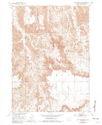
1951 Map of Cuny Table West
USGS Topo · Published 1981About this map
Pine Ridge Indian Reservation lands dominate this mid-century survey, showcasing a landscape defined by dramatic high plateaus and deep drainage systems. The topography is anchored by the massive Cuny Table and Red Shirt Table, expansive flat-topped landforms that rise sharply above the surrounding breaks. These geological features dictated the movement and settlement patterns of the region, as seen in the way Cedar Creek and Brush Creek carve through the terrain. The transition from the high elevations of Pine Ridge down into the intricate Battle Creek Canyon illustrates the complex erosional history of the Missouri River Basin development area. While the map is sparse in permanent structures, the named landmarks like Blindman Table provide essential points of reference for local-history researchers and genealogists tracing land allotments and family connections within the reservation during the late 1940s and early 1950s.
Find a feature on this map
9 named features on this map. Tap any name to fly to it.
Don’t see what you’re looking for? This feature index may not catch every label — zoom into the map to look around manually.
Map Details
Editions of this 1951 Cuny Table West Map
Other maps of this area

1950 · Cuny Table East
USGS Topo · 1:24,000

1951 · Red Shirt
USGS Topo · 1:24,000

1951 · Willow Creek NW
USGS Topo · 1:24,000

1951 · Heutmacher Table
USGS Topo · 1:24,000

1951 · Rockyford NW
USGS Topo · 1:24,000

1951 · Willow Creek NE
USGS Topo · 1:24,000

1951 · Red Shirt NE
USGS Topo · 1:24,000

1951 · Red Shirt SW
USGS Topo · 1:24,000

1951 · Cuny Table West
USGS Topo · 1:24,000

1955 · Hot Springs
USGS Topo · 1:250,000