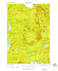
1931 Map of Cupsuptic
USGS Topo · Published 1958About this map
Upper Cupsuptic and the surrounding unorganized territories of Oxford County define this wilderness landscape along the international boundary and the Quebec border. Surveyed in the early 1930s, the map reveals a remote region driven by timber and sporting culture, where a complex network of camps like Cupsuptic Sporting Camp and Riverside Camp served woodsmen and visiting anglers. The drainage of the Cupsuptic River and its Big Canyon are central features, alongside the Central Maine railroad line which skirted the southeastern edge near Kennebago Lake. Landmarks such as the Parmachenee Club and the Fire Tower on West Kennebago Mtn indicate the era's dual focus on exclusive outdoor recreation and active forest fire monitoring. Small, functional outposts including Game Wardens Camp and the curiously named Moochers Home offer specific points of interest for local historians studying the human footprint in the Maine North Woods.
Find a feature on this map
100 named features on this map. Tap any name to fly to it.
Don’t see what you’re looking for? This feature index may not catch every label — zoom into the map to look around manually.
Map Details
Editions of this 1931 Cupsuptic Map
5 editions found
Other maps of this area

1927 · Moose Bog
USGS Topo · 1:48,000

1927 · Second Lake
USGS Topo · 1:62,500

1928 · Chain Lakes
USGS Topo · 1:48,000

1930 · Errol
USGS Topo · 1:62,500

1931 · Cupsuptic
USGS Topo · 1:48,000

1931 · Moose Bog
USGS Topo · 1:62,500

1932 · Kennebago Lake
USGS Topo · 1:48,000

1932 · Second Lake
USGS Topo · 1:62,500

1932 · Arnold Pond
USGS Topo · 1:48,000

1932 · Chain Lakes
USGS Topo · 1:62,500