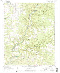
1968 Map of Cureall NW
USGS Topo · Published 1969About this map
North Fork River meanders through the heart of the Mark Twain National Forest, defining the rugged topography of Ozark County in the late 1960s. This survey records a landscape characterized by deep hollows and high ridges, where water is the primary architect. Named springs like Althea Spring, Rainbow Spring, and Bird Springs dot the terrain, while The Falls and the crossing at Duncan Ford highlight the river's historical importance for local travel.
Find a feature on this map
73 named features on this map. Tap any name to fly to it.
Don’t see what you’re looking for? This feature index may not catch every label — zoom into the map to look around manually.
Map Details
Editions of this 1968 Cureall NW Map
2 editions found
Other maps of this area

1934 · Gainesville
USGS Topo · 1:48,000

1937 · Buckhart
USGS Topo · 1:48,000

1939 · Topaz
USGS Topo · 1:62,500

1940 · Gainesville
USGS Topo · 1:62,500

1941 · Topaz
USGS Topo · 1:62,500

1943 · Buckhart
USGS Topo · 1:62,500

1944 · Cureall
USGS Topo · 1:62,500

1945 · Harrison
USGS Topo · 1:250,000

1945 · Buckhart
USGS Topo · 1:62,500

1946 · Cureall
USGS Topo · 1:62,500