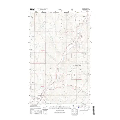
2014 Map of Curlew
USGS Topo · Published 2014About this map
Kettle River defines the central corridor of this northern Washington landscape, winding through a valley flanked by the steep slopes of the Colville National Forest. The settlement of Danville sits at the northern edge near the international border, while Curlew serves as the southern anchor. The transport network reflects the challenges of the terrain, with routes like Vulcan Mountain RD and Scott Mountain RD navigating the high ground around Drummer Mtn. Local infrastructure is concentrated along the riverbanks, where the Kettle River Bridge and Curlew Bridge provide essential crossings. Small tributaries such as Shasket Cr and Goosmus Creek feed into the main valley, marking the drainages that have shaped the region's rural development and land use patterns.
Find a feature on this map
60 named features on this map. Tap any name to fly to it.
Don’t see what you’re looking for? This feature index may not catch every label — zoom into the map to look around manually.
Map Details
Editions of this 2014 Curlew Map
This is the sole edition of this map. No revisions or reprints were ever made.
Other maps of this area

1904 · Republic
USGS Topo · 1:125,000

1936 · Marcus
USGS Topo · 1:96,000

1942 · Marcus
USGS Topo · 1:125,000

1948 · Curlew
USGS Topo · 1:62,500

1948 · Togo Mountain
USGS Topo · 1:62,500

1951 · Togo Mountain
USGS Topo · 1:62,500

1951 · Curlew
USGS Topo · 1:62,500

1954 · Okanogan
USGS Topo · 1:250,000

1958 · Okanogan
USGS Topo · 1:250,000
1983 · Boundary Mtn
USGS Topo · 1:24,000