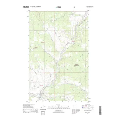
2020 Map of Curlew
USGS Topo · Published 2020About this map
The Kettle River meanders through this rugged corridor of Ferry County, defining the valley that connects the settlements of Danville and Curlew. This mountainous terrain is anchored by Lafleur Mountain and Drummer Mtn, with a significant portion of the landscape managed as part of the Colville National Forest. The map documents a legacy of resource extraction, noting the Vulcan and Little Vulcan sites tucked into the western slopes. Transportation infrastructure is vital in this steep geography, highlighted by the Curlew Bridge and Kettle River Bridge, which provide essential crossings for the local road network. Numerous drainage systems like Goosmus Cr, Long Alec Cr, and Day Creek feed the main river, illustrating the complex hydrology that shaped the region's development during the late twentieth and early twenty-first centuries.
Find a feature on this map
81 named features on this map. Tap any name to fly to it.
Don’t see what you’re looking for? This feature index may not catch every label — zoom into the map to look around manually.
Map Details
Editions of this 2020 Curlew Map
This is the sole edition of this map. No revisions or reprints were ever made.
Other maps of this area

1904 · Republic
USGS Topo · 1:125,000

1936 · Marcus
USGS Topo · 1:96,000

1942 · Marcus
USGS Topo · 1:125,000

1948 · Curlew
USGS Topo · 1:62,500

1948 · Togo Mountain
USGS Topo · 1:62,500

1951 · Togo Mountain
USGS Topo · 1:62,500

1951 · Curlew
USGS Topo · 1:62,500

1954 · Okanogan
USGS Topo · 1:250,000

1958 · Okanogan
USGS Topo · 1:250,000
1983 · Boundary Mtn
USGS Topo · 1:24,000