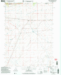
2001 Map of Curlew Junction
USGS Topo · Published 2006About this map
California National Historic Trail segments cross this high-desert landscape, marking the enduring legacy of westward migration through the Curlew Valley. The map details the California NHT (Salt Lake Cut-Off), a critical corridor for 19th-century travelers seeking a reliable route toward the Great Salt Lake. This 2001 revision by the Forest Service highlights a landscape where water management and transportation history converge, featuring an extensive aqueduct system alongside historical waypoints like Pilot Spring. The presence of the Sawtooth National Forest in the northwest corner and the remote Curlew Junction crossroads illustrates the intersection of public land management and rural connectivity. Smaller features such as a Corral, a Trough, and numerous wells indicate the area's continued use for livestock and land stewardship at the turn of the 21st century.
Find a feature on this map
17 named features on this map. Tap any name to fly to it.
Don’t see what you’re looking for? This feature index may not catch every label — zoom into the map to look around manually.
Map Details
Editions of this 2001 Curlew Junction Map
This is the sole edition of this map. No revisions or reprints were ever made.
Other maps of this area

1954 · Pocatello
USGS Topo · 1:250,000

1954 · Brigham City
USGS Topo · 1:250,000

1958 · Pocatello
USGS Topo · 1:250,000

1958 · Brigham City
USGS Topo · 1:250,000

1959 · Strevell
USGS Topo · 1:62,500

1959 · Kelton Pass
USGS Topo · 1:62,500

1962 · Brigham City
USGS Topo · 1:250,000

1968 · Monument Peak NW
USGS Topo · 1:24,000

1968 · Monument Peak SW
USGS Topo · 1:24,000

1973 · Black Pine
USGS Topo · 1:24,000