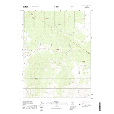
2018 Map of Currant Summit
USGS Topo · Published 2018About this map
The White Pine Range and Horse Range dominate the high-altitude topography of this 2018 survey, centered on the divide between Nye and White Pine counties. This part of the Great Basin is characterized by internal drainage and intermittent water sources, evidenced by names like Secret Spring, Hidden Spring, and Summit Spring. Human activity is primarily oriented toward resource management and navigation through the peaks. Significant landmarks include Currant Summit and Wilhoites Peak, while the northern portion of the quadrangle is occupied by the Humboldt National Forest. In the west, the Manzonie Reservoir collects the waters of Currant Cr. Remote access is facilitated by the Gold Mine Trail and service routes such as Radio Towers Rd, highlighting the region's sparse infrastructure and focus on mining and communications.
Find a feature on this map
28 named features on this map. Tap any name to fly to it.
Don’t see what you’re looking for? This feature index may not catch every label — zoom into the map to look around manually.
Map Details
Editions of this 2018 Currant Summit Map
This is the sole edition of this map. No revisions or reprints were ever made.
Other maps of this area

1956 · Lund
USGS Topo · 1:250,000

1957 · Currant Mtn
USGS Topo · 1:62,500

1960 · Lund
USGS Topo · 1:250,000

1964 · Currant
USGS Topo · 1:62,500

1964 · Currant Mtn
USGS Topo · 1:62,500

1969 · Moorman Spring NW
USGS Topo · 1:24,000
1978 · Douglas
USGS Topo · 1:24,000
1978 · Badger Hole Spring
USGS Topo · 1:24,000

1980 · Duckwater
USGS Topo · 1:100,000
1990 · Currant
USGS Topo · 1:24,000