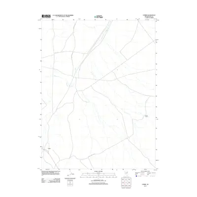
2012 Map of Currie
USGS Topo · Published 2012About this map
Currie serves as the central point of reference in this northeastern Nevada landscape, where the high desert terrain is defined by its network of seasonal drainage and long-distance access roads. The transportation routes, such as Goshute Valley Rd and the intriguing Victoria Mine Back Rd, speak to the region's reliance on connecting remote settlements and industrial sites. The topography is shaped by watercourses like Nelson Cr and Phalen Cr, which flow toward the lower elevations of the valley. To the east, the entrance to Currie Canyon provides a natural break in the rising terrain, illustrating the historical movement patterns of travelers through the Great Basin. This 2012 survey by the U.S. Geological Survey documents the rural infrastructure and land use in Elko County, capturing the sparse but critical geography of the Goshute Valley area.
Find a feature on this map
7 named features on this map. Tap any name to fly to it.
Don’t see what you’re looking for? This feature index may not catch every label — zoom into the map to look around manually.
Map Details
Editions of this 2012 Currie Map
This is the sole edition of this map. No revisions or reprints were ever made.
Other maps of this area

1955 · Elko
USGS Topo · 1:250,000

1958 · Elko
USGS Topo · 1:250,000

1962 · Elko
USGS Topo · 1:250,000

1965 · Elko
USGS Topo · 1:250,000

1982 · Currie
USGS Topo · 1:24,000

1982 · Sharp Peak
USGS Topo · 1:24,000
1982 · Goshute Lake NE
USGS Topo · 1:24,000

1982 · Mizpah
USGS Topo · 1:24,000
1982 · Mizpah Point
USGS Topo · 1:24,000
1982 · Goshute Lake North
USGS Topo · 1:24,000