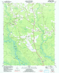
1983 Map of Currie
USGS Topo · Published 1992About this map
Moores Creek Nat Battlefield anchors the western edge of this coastal plain landscape, preserving the site where the North Carolina swamp terrain influenced Revolutionary history. The area is defined by a complex network of waterways, including the Black River and its associated features like Thorofare Island, Birds Cove Island, and Herrings Neck. These wetlands are interspersed with unique elliptical depressions such as Currie of the Railroad Bay, Horsepen Bay, and Lee Hugh Bay, reflecting the distinct geology of the region.
Find a feature on this map
75 named features on this map. Tap any name to fly to it.
Don’t see what you’re looking for? This feature index may not catch every label — zoom into the map to look around manually.
Map Details
Editions of this 1983 Currie Map
2 editions found
Other maps of this area

1942 · Burgaw
USGS Topo · 1:62,500

1947 · Rocky Point
USGS Topo · 1:62,500

1953 · Florence
USGS Topo · 1:250,000

1953 · Beaufort
USGS Topo · 1:250,000

1954 · Florence
USGS Topo · 1:250,000

1954 · Beaufort
USGS Topo · 1:250,000

1954 · Acme
USGS Topo · 1:62,500

1955 · Atkinson
USGS Topo · 1:62,500
1970 · Castle Hayne
USGS Topo · 1:24,000
1970 · Rocky Point
USGS Topo · 1:24,000