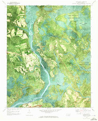
1970 Map of Mooretown
USGS Topo · Published 1973About this map
The Northeast Cape Fear River dominates this 1970s orthophotomap, winding through a landscape defined by extensive wetlands and scattered rural settlements. Along its western banks lies Mooretown, a community situated near industrial sites like a Sandpit and a Quarry at the southern edge of the sheet. For genealogists, the map identifies local burial grounds such as Ashe Cem near the river and Union Chapel Cem further inland to the east.
Find a feature on this map
20 named features on this map. Tap any name to fly to it.
Don’t see what you’re looking for? This feature index may not catch every label — zoom into the map to look around manually.
Map Details
Editions of this 1970 Mooretown Map
This is the sole edition of this map. No revisions or reprints were ever made.
Other maps of this area

1942 · Topsail
USGS Topo · 1:62,500

1942 · Burgaw
USGS Topo · 1:62,500

1947 · Rocky Point
USGS Topo · 1:62,500

1948 · Maple Hill
USGS Topo · 1:62,500

1948 · Topsail
USGS Topo · 1:62,500

1953 · Beaufort
USGS Topo · 1:250,000

1954 · Beaufort
USGS Topo · 1:250,000

1970 · Hampstead
USGS Topo · 1:24,000

1970 · Topsail
USGS Topo · 1:24,000

1970 · Scotts Hill
USGS Topo · 1:24,000