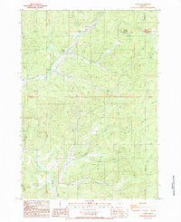
1987 Map of Curtin
USGS Topo · Published 1987About this map
Pass Creek carves a narrow corridor through the timbered hills of Douglas County, serving as the primary passage for both the Southern Pacific railroad and the highway. This 1987 survey documents the small settlements that grew along these transportation lines, including Comstock, Anlauf, and Curtin. The landscape is defined by the steep drainage systems of Elk Creek and Bear Creek, which converge in a region where local industry is represented by scattered quarries and the management of rugged forest tracts.
Find a feature on this map
27 named features on this map. Tap any name to fly to it.
Don’t see what you’re looking for? This feature index may not catch every label — zoom into the map to look around manually.
Map Details
Editions of this 1987 Curtin Map
This is the sole edition of this map. No revisions or reprints were ever made.
Other maps of this area

1921 · Cottage Grove
USGS Topo · 1:62,500

1942 · Crow
USGS Topo · 1:62,500

1945 · Crow
USGS Topo · 1:62,500

1954 · Drain
USGS Topo · 1:62,500

1954 · Anlauf
USGS Topo · 1:62,500
1957 · Cottage Grove
USGS Topo · 1:62,500

1958 · Roseburg
USGS Topo · 1:250,000

1959 · Roseburg
USGS Topo · 1:250,000

1979 · Cottage Grove
USGS Topo · 1:100,000
1984 · Cottage Grove
USGS Topo · 1:24,000