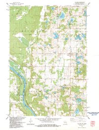
1983 Map of Cushing
USGS Topo · Published 1983About this map
Cushing and the rural townships of Sterling and Eureka define this landscape in the early 1980s, situated just east of the Minnesota border. The topography is dominated by a dense concentration of glacial water bodies, including Wolf Lake, Big Lake, and the uniquely named Mud Lake and Pine Island Lake. Along the western edge, the St Croix National Scenic Riverway and St Croix Wild River State Park protect the river corridor, which was once a vital artery for the region's timber industry. A significant piece of this history is preserved at the Nevers Dam Site, once home to one of the world's largest wood-piling dams. The map also reveals the area's agricultural and social fabric through its network of numbered avenues, localized Gravel Pits, and small community centers like Wolf Creek and Eureka Center.
Find a feature on this map
54 named features on this map. Tap any name to fly to it.
Don’t see what you’re looking for? This feature index may not catch every label — zoom into the map to look around manually.
Map Details
Editions of this 1983 Cushing Map
This is the sole edition of this map. No revisions or reprints were ever made.
Other maps of this area

1900 · St Croix Dalles
USGS Topo · 1:62,500

1901 · St Croix Dalles
USGS Topo · 1:62,500

1950 · Rush City
USGS Topo · 1:48,000

1951 · Milltown
USGS Topo · 1:48,000

1953 · Stillwater
USGS Topo · 1:250,000

1955 · St. Croix Dalles
USGS Topo · 1:62,500

1955 · Rush City
USGS Topo · 1:62,500

1955 · Milltown
USGS Topo · 1:62,500

1955 · Forest Lake
USGS Topo · 1:62,500

1955 · Stillwater
USGS Topo · 1:250,000