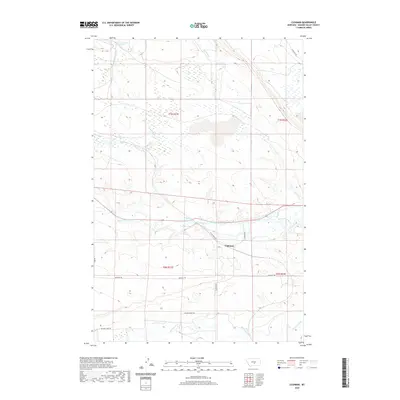
2020 Map of Cushman
USGS Topo · Published 2020About this map
The settlement of Cushman serves as a focal point in this central Montana landscape, situated where W Cushman Rd meets the winding course of the Musselshell River. The map illustrates a high plains environment defined by its water sources and long-established transit corridors. Significant drainage systems include Ninemile Cr and Fivemile Cr to the north, while Big Coulee Cr cuts through the southern sections. Local history and ranching heritage are evident in the named trails and roads such as Buffalo Trl and Van Der Voort Rd, which traverse the township boundaries of T6N and T7N. Notable water features like Ninemile Spring highlight the critical role of reliable water in this arid region, providing a detailed look at the geography of Golden Valley County.
Find a feature on this map
16 named features on this map. Tap any name to fly to it.
Don’t see what you’re looking for? This feature index may not catch every label — zoom into the map to look around manually.
Map Details
Editions of this 2020 Cushman Map
This is the sole edition of this map. No revisions or reprints were ever made.
Other maps of this area

1889 · Big Snowy Mountain
USGS Topo · 1:250,000

1893 · Big Snowy Mountain
USGS Topo · 1:250,000

1954 · Roundup
USGS Topo · 1:250,000

1958 · Roundup
USGS Topo · 1:250,000

1979 · Roundup
USGS Topo · 1:100,000

1979 · Lavina NW
USGS Topo · 1:24,000

1979 · Lavina
USGS Topo · 1:24,000

1979 · Belmont
USGS Topo · 1:24,000
1985 · Mount Sinai
USGS Topo · 1:24,000
1985 · Eagle Point
USGS Topo · 1:24,000