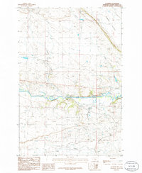
1986 Map of Cushman
USGS Topo · Published 1986About this map
The Musselshell River carves a deep valley across this central Montana landscape, serving as the primary geographical anchor for the small settlement of Cushman. The terrain is defined by a network of drainage systems, including Ninemile Creek and Fivemile Creek, which lead toward the river through a region marked by coulees and draws. To the north, the distinctive landform of Womans Pocket overlooks the valley floor. Evidence of the area's development is seen in the Old RR Grade and a Landing Strip, suggesting a transition in transportation and land use over time. Industrial and agricultural infrastructure is present through several Gravel Pit operations and a Concrete Dam on the river, while the local hydrology is punctuated by features like Dry Lake and Ninemile Spring.
Find a feature on this map
16 named features on this map. Tap any name to fly to it.
Don’t see what you’re looking for? This feature index may not catch every label — zoom into the map to look around manually.
Map Details
Editions of this 1986 Cushman Map
This is the sole edition of this map. No revisions or reprints were ever made.
Other maps of this area

1889 · Big Snowy Mountain
USGS Topo · 1:250,000

1893 · Big Snowy Mountain
USGS Topo · 1:250,000

1954 · Roundup
USGS Topo · 1:250,000

1958 · Roundup
USGS Topo · 1:250,000

1979 · Roundup
USGS Topo · 1:100,000

1979 · Lavina NW
USGS Topo · 1:24,000

1979 · Lavina
USGS Topo · 1:24,000

1979 · Belmont
USGS Topo · 1:24,000
1985 · Mount Sinai
USGS Topo · 1:24,000
1985 · Eagle Point
USGS Topo · 1:24,000