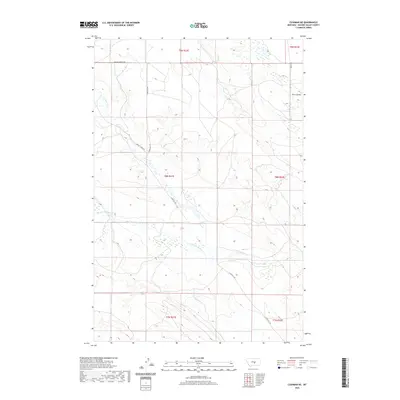
2020 Map of Cushman NE
USGS Topo · Published 2020About this map
Currant Cr meanders through this section of Golden Valley County, carving a path through the expansive prairie landscape of central Montana. The map documents a sparsely populated ranching region where drainage systems like Merrills Springs Cr and Fivemile Cr define the movement of water across the high plains. Human activity is primarily traced through the network of rural roads that follow the section lines and natural contours, including Womans Pocket Rd and E Red Hill Rd. The small settlement at Twin Coulee stands as a focal point in the northeast, while the remainder of the terrain is organized by the Public Land Survey System, marked by township boundaries like t8n r21e and t7n r22e. This survey provides a clear look at the modern rural infrastructure and water resources essential for life in this part of the Big Sky Country.
Find a feature on this map
14 named features on this map. Tap any name to fly to it.
Don’t see what you’re looking for? This feature index may not catch every label — zoom into the map to look around manually.
Map Details
Editions of this 2020 Cushman NE Map
This is the sole edition of this map. No revisions or reprints were ever made.
Other maps of this area

1889 · Big Snowy Mountain
USGS Topo · 1:250,000

1893 · Big Snowy Mountain
USGS Topo · 1:250,000

1954 · Roundup
USGS Topo · 1:250,000

1958 · Roundup
USGS Topo · 1:250,000

1979 · Roundup
USGS Topo · 1:100,000

1979 · Lavina NW
USGS Topo · 1:24,000

1979 · Lavina
USGS Topo · 1:24,000
1986 · Ryegate East
USGS Topo · 1:24,000

1986 · Emory School
USGS Topo · 1:24,000

1986 · Cushman NW
USGS Topo · 1:24,000