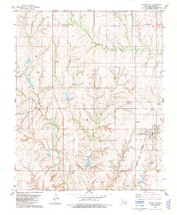
1983 Map of Custer City
USGS Topo · Published 1984About this map
Custer City serves as the focal point of this western Oklahoma landscape, situated at the boundary between Grant and Arapaho townships. The town's layout reflects a classic prairie rail-and-agriculture settlement, centered on the Burlington Northern and Santa Fe Atchison Topeka railroad line. Local social and civic foundations are visible through the presence of the Custer City Sch and the Masonic Cem, along with the Independence Cem located to the north.
Find a feature on this map
17 named features on this map. Tap any name to fly to it.
Don’t see what you’re looking for? This feature index may not catch every label — zoom into the map to look around manually.
Map Details
Editions of this 1983 Custer City Map
This is the sole edition of this map. No revisions or reprints were ever made.
Other maps of this area

1955 · Clinton
USGS Topo · 1:250,000

1957 · Clinton
USGS Topo · 1:250,000

1957 · Butler
USGS Topo · 1:62,500

1957 · Clinton
USGS Topo · 1:62,500

1962 · Putnam
USGS Topo · 1:62,500

1962 · Aledo
USGS Topo · 1:62,500

1976 · Clinton SE
USGS Topo · 1:24,000

1976 · Butler NE
USGS Topo · 1:24,000

1976 · Clinton SW
USGS Topo · 1:24,000

1976 · Clinton NW
USGS Topo · 1:24,000