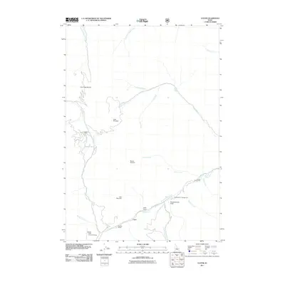
2011 Map of Custer
USGS Topo · Published 2011About this map
The settlement of Custer serves as the focal point for this survey of the Salmon River Mountains, where high-altitude mining and recreation define the landscape. The Yankee Fork and its many tributaries, including Greylock Creek and Eightmile Creek, carve through a topography marked by significant peaks such as Estes Mountain and Mount Greylock. Evidence of the region's industrial heritage is clearly visible near the southern reaches of the map, notably at the site of the Yankee Fork Dredge and the Sunbeam Mine further north along Jordan Creek.
Find a feature on this map
27 named features on this map. Tap any name to fly to it.
Don’t see what you’re looking for? This feature index may not catch every label — zoom into the map to look around manually.
Map Details
Editions of this 2011 Custer Map
This is the sole edition of this map. No revisions or reprints were ever made.
Other maps of this area

1919 · Custer
USGS Topo · 1:125,000

1922 · Custer
USGS Topo · 1:125,000

1930 · Casto
USGS Topo · 1:125,000

1957 · Challis
USGS Topo · 1:250,000

1960 · Challis
USGS Topo · 1:250,000

1963 · Challis
USGS Topo · 1:250,000

1963 · Challis Creek Lakes
USGS Topo · 1:24,000

1963 · Custer
USGS Topo · 1:24,000

1963 · Casto
USGS Topo · 1:24,000
1963 · Elevenmile Creek
USGS Topo · 1:24,000