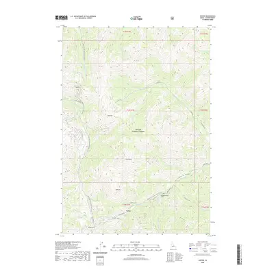
2020 Map of Custer
USGS Topo · Published 2020About this map
The high mountain settlement of Custer serves as the focal point for this terrain within the Challis National Forest. Situated along the Yankee Fork, the landscape is defined by steep drainages and prominent peaks, including Bald Mountain and Mt Greylock. Historical mining activity is implied by the nomenclature of surrounding ravines such as Swift Gulch, Puzzler Gulch, and Slaughterhouse Gulch.
Find a feature on this map
38 named features on this map. Tap any name to fly to it.
Don’t see what you’re looking for? This feature index may not catch every label — zoom into the map to look around manually.
Map Details
Editions of this 2020 Custer Map
This is the sole edition of this map. No revisions or reprints were ever made.
Other maps of this area

1919 · Custer
USGS Topo · 1:125,000

1922 · Custer
USGS Topo · 1:125,000

1930 · Casto
USGS Topo · 1:125,000

1957 · Challis
USGS Topo · 1:250,000

1960 · Challis
USGS Topo · 1:250,000

1963 · Challis
USGS Topo · 1:250,000

1963 · Challis Creek Lakes
USGS Topo · 1:24,000

1963 · Custer
USGS Topo · 1:24,000

1963 · Casto
USGS Topo · 1:24,000
1963 · Elevenmile Creek
USGS Topo · 1:24,000