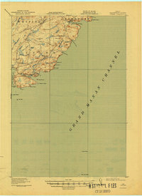
1918 Map of Cutler
USGS Topo · Published 1944About this map
The coastal village of Cutler sits tucked along a harbor protected by Little River I, serving as a primary point of settlement along this stretch of the Washington County shoreline. Surveyed in the early twentieth century, the landscape reflects a seafaring and rural character, with scattered educational landmarks like School No 21 and the Moose River School serving the remote townships of Trescott and Whiting.
Find a feature on this map
41 named features on this map. Tap any name to fly to it.
Don’t see what you’re looking for? This feature index may not catch every label — zoom into the map to look around manually.
Map Details
Editions of this 1918 Cutler Map
5 editions found
Other maps of this area

1907 · Eastport
USGS Topo · 1:48,000

1908 · Eastport
USGS Topo · 1:62,500

1917 · Cutler
USGS Topo · 1:62,500

1918 · Machias
USGS Topo · 1:62,500

1918 · Cutler
USGS Topo · 1:62,500

1941 · Machias
USGS Topo · 1:62,500

1941 · Gardner Lake
USGS Topo · 1:62,500

1943 · Gardner Lake
USGS Topo · 1:62,500

1943 · Eastport
USGS Topo · 1:62,500

1945 · Eastport
USGS Topo · 1:62,500