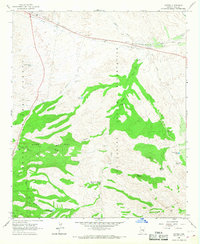
1966 Map of Cutter
USGS Topo · Published 1968About this map
The San Carlos Indian Reservation and Tonto National Forest meet in this mid-century survey of the Arizona landscape, where the Southern Pacific railroad corridor dictates the path of development. The small settlement of Cutter sits at the junction of the rails and the Globe Municipal Airport, serving as a localized transport hub for the surrounding ranching operations. Away from the railroad, the terrain is defined by a network of essential water sources including Haunted Spring, Cutter Tank, and the Hole in the Rock Tank.
Find a feature on this map
44 named features on this map. Tap any name to fly to it.
Don’t see what you’re looking for? This feature index may not catch every label — zoom into the map to look around manually.
Map Details
Editions of this 1966 Cutter Map
This is the sole edition of this map. No revisions or reprints were ever made.
Other maps of this area

1901 · Globe
USGS Topo · 1:62,500

1902 · Globe
USGS Topo · 1:62,500

1910 · Ray
USGS Topo · 1:62,500

1915 · Christmas
USGS Topo · 1:62,500

1917 · Christmas
USGS Topo · 1:62,500

1945 · Globe
USGS Topo · 1:24,000

1954 · Mesa
USGS Topo · 1:250,000

1957 · Mesa
USGS Topo · 1:250,000

1958 · Mesa
USGS Topo · 1:250,000

1960 · Mesa
USGS Topo · 1:250,000