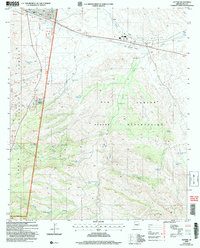
2004 Map of Cutter
USGS Topo · Published 2007About this map
The San Carlos Apache Reservation and the Tonto National Forest meet in this landscape of high desert washes and rugged peaks, defined by a complex network of springs and water tanks. The settlement of Cutter sits at the northern edge, adjacent to the Globe Municipal Airport and along the vital corridor of the Rambo Wash. The terrain is marked by family-named ranching sites such as Cutter Ranch and the Bar F Bar Ranch, indicating the cattle-rearing history of the Gila County region.
Find a feature on this map
53 named features on this map. Tap any name to fly to it.
Don’t see what you’re looking for? This feature index may not catch every label — zoom into the map to look around manually.
Map Details
Editions of this 2004 Cutter Map
This is the sole edition of this map. No revisions or reprints were ever made.
Other maps of this area

1901 · Globe
USGS Topo · 1:62,500

1902 · Globe
USGS Topo · 1:62,500

1910 · Ray
USGS Topo · 1:62,500

1915 · Christmas
USGS Topo · 1:62,500

1917 · Christmas
USGS Topo · 1:62,500

1945 · Globe
USGS Topo · 1:24,000

1954 · Mesa
USGS Topo · 1:250,000

1957 · Mesa
USGS Topo · 1:250,000

1958 · Mesa
USGS Topo · 1:250,000

1960 · Mesa
USGS Topo · 1:250,000