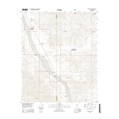
2015 Map of Cuyama Peak
USGS Topo · Published 2015About this map
Ventucopa sits as a primary point of reference in this arid landscape where the Cuyama Valley meets the high elevations of the San Emigdio Mountains. This survey illustrates a complex network of drainage systems feeding into the valley floor, characterized by deep incisions like Quatal Canyon, Pato Canyon, and Deer Park Canyon. Much of the eastern and northern territory falls within the Los Padres National Forest, where the terrain rises toward the prominent Cuyama Peak at the southern edge. The map captures the meeting point of the Santa Barbara and Ventura County lines, showing how local infrastructure like Quatal Canyon Rd and El Roblar St navigates the transition from the relatively flat valley agriculture to the steep, rugged wilderness of the national forest.
Find a feature on this map
21 named features on this map. Tap any name to fly to it.
Don’t see what you’re looking for? This feature index may not catch every label — zoom into the map to look around manually.
Map Details
Editions of this 2015 Cuyama Peak Map
This is the sole edition of this map. No revisions or reprints were ever made.
Other maps of this area

1902 · Santa Ynez
USGS Topo · 1:125,000

1903 · Mt. Pinos
USGS Topo · 1:125,000

1905 · Santa Ynez
USGS Topo · 1:125,000

1942 · Ballinger Canyon
USGS Topo · 1:24,000

1942 · East of Cuyama Ranch
USGS Topo · 1:24,000

1943 · Rancho Nuevo Creek
USGS Topo · 1:24,000

1943 · Apache Canyon
USGS Topo · 1:24,000

1943 · Santiago Creek
USGS Topo · 1:24,000
1943 · Ballinger Canyon
USGS Topo · 1:24,000

1943 · Cuyama Peak
USGS Topo · 1:24,000