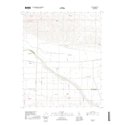
2018 Map of Cuyama
USGS Topo · Published 2018About this map
Cuyama serves as the central hub of this arid valley landscape, positioned just south of the Cuyama River and the Wash. The settlement pattern follows the dictates of the high desert terrain, with roads like Schaeffer Rd and Foothill Rd stretching across the alluvial flats toward the steep slopes of the Caliente Range. The presence of Vosburgh Airfield highlights the importance of aerial access in this expansive environment. To the north and south, the topography is defined by complex drainage systems, including Quail Canyon and the branching paths of Goode Canyon and Tennison Canyon. The map records a distinct boundary where San Luis Obispo and Santa Barbara counties meet along the riverbed, illustrating how natural features define administrative borders in this part of California.
Find a feature on this map
31 named features on this map. Tap any name to fly to it.
Don’t see what you’re looking for? This feature index may not catch every label — zoom into the map to look around manually.
Map Details
Editions of this 2018 Cuyama Map
This is the sole edition of this map. No revisions or reprints were ever made.
Other maps of this area

1902 · Santa Ynez
USGS Topo · 1:125,000

1903 · Mt. Pinos
USGS Topo · 1:125,000

1905 · Santa Ynez
USGS Topo · 1:125,000

1910 · Buena Vista Lake
USGS Topo · 1:125,000

1912 · McKittrick
USGS Topo · 1:125,000

1912 · Buena Vista Lake
USGS Topo · 1:125,000

1942 · Ballinger Canyon
USGS Topo · 1:24,000

1942 · East of Cuyama Ranch
USGS Topo · 1:24,000

1943 · Maricopa
USGS Topo · 1:31,680

1943 · Cuyama Ranch
USGS Topo · 1:31,680