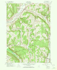
1943 Map of Cuyler
USGS Topo · Published 1981About this map
The East Branch Tioughnioga River and the Lehigh Valley railroad corridor define the settlement patterns of this central New York landscape during the early 1940s. The valley floor hosts the primary villages of Cuyler and Tripoli, while the surrounding uplands are marked by a dispersed network of rural districts. This terrain is characterized by numerous family-named peaks, such as Pease Hill, Bull Hill, and Seacord Hill, which separated small communities and dictated the placement of one-room schoolhouses.
Find a feature on this map
37 named features on this map. Tap any name to fly to it.
Don’t see what you’re looking for? This feature index may not catch every label — zoom into the map to look around manually.
Map Details
Editions of this 1943 Cuyler Map
4 editions found


Other maps of this area

1897 · Cazenovia
USGS Topo · 1:62,500

1899 · Cazenovia
USGS Topo · 1:62,500

1900 · Tully
USGS Topo · 1:62,500

1903 · Cortland
USGS Topo · 1:62,500

1904 · Pitcher
USGS Topo · 1:62,500
1943 · Tully
USGS Topo · 1:24,000

1943 · De Ruyter
USGS Topo · 1:24,000

1943 · South Ostelic
USGS Topo · 1:24,000

1943 · Cincinnatus
USGS Topo · 1:24,000
1943 · Erieville
USGS Topo · 1:24,000